Geodetic Surveying Instruments, features, types
Geodetic Surveying Instruments, features, types
What are Geodetic Surveying Instruments?
They are specialized tools used by surveyors to measure and map the Earth's surface with a high degree of accuracy. These devices are designed to determine the exact locations, distances, angles and elevations of points on the Earth's surface.
Tools for surney:
Here are some commonly used topographic survey tools:
Global Navigation Satellite System (GNSS) receivers: GNSS, such as Global Positioning System (GPS) receivers, receive signals from multiple satellites to locate a point on the Earth's surface.
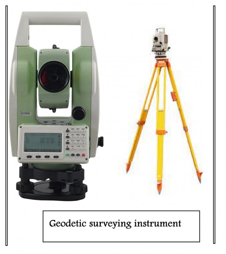
Total Stations: Total stations combine electronic distance measurement (EDM) and electronic theodolites. They are used to measure distances, angles and heights. Total stations often include a reflectorless mode that allows measurements to be taken without the use of a prism.
Theodolites: Theodolites are optical instruments used to measure horizontal and vertical angles. They consist of a telescope mounted on a base with setting circles that allow accurate angle measurements.
laser scanner: Laser scanners use laser beams to capture three-dimensional information about the shape and characteristics of objects or terrain. They can create highly detailed point clouds that are used to create digital terrain models and 3D renderings.
Digital levels: Digital spirit levels are used to accurately measure height differences and elevations. They use electronic sensors to measure the vertical distance between two points.
Electronic Rangefinders (EDM): EDM devices use electromagnetic waves or laser beams to accurately measure distances between points. They can be integrated into total stations or used as stand-alone devices.
Inertial Measurement Units (IMU): IMUs are used to measure changes in position, attitude, and acceleration. They are often used in conjunction with GNSS receivers to provide accurate positioning even in challenging environments.
Leveling Tools: Leveling tools, such as auto levels or grade levels, are used to measure height differences and create level surfaces. They consist of a telescope and a spirit level.
Magnetic compass. While not as accurate as other instruments, a magnetic compass can be used for basic orientation and direction measurements in the field.
Types of geodetic surveys:
There are several types of detection, including:
Control Investigation: This type of investigation is used to create a network of checkpoints in the area that all subsequent investigations will connect to. Control studies are the basis for accurate mapping and investigations.
Topographic Survey: A thorough map of the surface features of a specific area is produced using topographic surveys.A topographic survey reveals the contours, altitudes, natural features like rivers and lakes, as well as man-made structures like buildings and highways.
Cadastral Survey: These surveys are used to define the limits of land ownership.Maps displaying property lines, parcel dimensions, and other crucial details pertaining to land ownership are produced using land surveys.
Engineering Survey: This type of survey is used to provide accurate measurements in the design and construction of engineering objects such as roads, bridges and buildings. Engineering surveys are used to determine the height, location and orientation of building elements.
Hydrographic Survey: This type of survey is used to map and measure underwater features such as ocean floors, riverbeds, and lakes. Hydrographic surveys are used in oceanography, wildlife management and navigation.
Astronomical Survey: This type of survey uses astronomical observations to determine your location and orientation on the Earth's surface. Astronomical research uses precise measurements of celestial bodies to determine latitude, longitude, and azimuth.
Features of the geodesic:
1)Accuracy: Geodetic surveys require precise measurements of the Earth's surface, often accurate to the millimeter or even smaller units. This accuracy is essential for accurate mapping and surveying.
2)Global Reach: Surveying can be used to create maps and models of the entire Earth's surface, making it a truly global area of study.
3)Use of advanced technologies: Surveying relies heavily on advanced technologies, including GPS receivers, total stations, laser scanners and other advanced instruments.
4)Many uses: Among its many useful applications are mapping, building, land management, environmental monitoring, and navigation.
5) Integration with different fields of study: Geology, geography, astronomy, and physics are all closely tied to surveying. This interdisciplinary approach gives surveyors a better understanding of the Earth's surface and the forces that shape it.
6)High level of skill and training: Surveying demands a high level of training and competence, as well as a thorough comprehension of cutting-edge physics, mathematics, and technology.
Uses:
There are many different sectors and applications for geodetic survey instruments. Here are some common uses for these tools:
Surveying: Surveying tools are widely used in surveying to define property boundaries, create topographic maps, and establish control points for construction projects. They help surveyors measure distances, angles and heights with high accuracy.
Construction and Engineering: Surveying tools play a vital role in construction and engineering projects. They are used to mark the foundations of buildings, roads, bridges and other infrastructure based on design plans. These tools ensure that the project meets the expected specifications.
Mapping and cartography: Surveying tools are used to create accurate maps and diagrams. They provide accurate location data that allows cartographers and GIS (Geographic Information System) professionals to create detailed maps for a variety of purposes, including urban planning, environmental management, and resource research.
Navigation and positioning: Global Navigation Satellite System (GNSS) receivers, like GPS devices, are often used for navigation and positioning purposes. They provide real-time location information for vehicles, ships, aircraft and individuals. GNSS receivers are also used in precision farming, research drones and other autonomous systems.
Geodesy and earth sciences: Surveying tools are essential in geodesy, the science of measuring and understanding the shape, gravitational field and rotation of the Earth. These instruments are used to track tectonic plate movements, study crustal deformation and measure sea level changes. They help scientists understand Earth's geophysical processes and contribute to geophysical models.
Environmental Monitoring: Survey tools are used in environmental monitoring to measure and track changes in the landscape, including erosion, subsidence, and land deformation. They help monitor coastal areas, monitor the stability of dams and infrastructure, and assess the impact of natural disasters.
Archeology and Cultural Heritage Conservation: Surveying instruments are used in archaeological research and cultural heritage conservation. They help document and map archaeological sites, ancient structures and monuments with high accuracy. These tools aid efforts to preserve and restore historic sites.
Mining and Exploration: Geodetic resources are used in mining and exploration. They help define the boundaries and contours of mine sites, monitor subsidence, measure landfill volume and map underground tunnels.
What's Your Reaction?