LIDAR, parts, types,uses
LIDAR, parts, types, uses
Stands for?
LIDAR stands for Light Detection and Ranging. It is a remote sensing technology that uses laser light to measure distances and create highly accurate 3D maps or models of objects and the environment.
Define:
This is a popular remote sensing technique used to measure the exact distance to an object on the Earth's surface.
Brief history:
1930: Three decades before the invention of lasers, scientists experiment with measuring the composition of the atmosphere using long-beam searchlights.
In 1958, Charles Townes and Arthur Shavlov create the maser, the first microwave laser.Gordon Gould also makes significant contributions.
1960: The first practical laser is constructed by Theodor Maiman, who also performs a demonstration.
1962: The distance from the Earth and the Moon was calculated in 1962 by MIT researchers using a reflected laser beam.
1965: Ronald Collins of the Stanford Research Institute files a patent for a LIDAR laser radar system that can be used to study the Earth's atmosphere and climate.
1969: Daniel Hickman and John Hogg publish an influential scientific paper describing how airborne lasers could be used to measure the depth of the ocean.
1971: Apollo 15 astronauts use lidar to map the lunar surface.
1973: NASA's Wallops Island Flight Center hosts a symposium [PDF] on using lidar to observe oceans and coastlines.
1974: dr. Alan Carswell of York University in Toronto invents the laser rangefinder and sets up Optech with his student Sebastian Sizgorik to commercialize it. Over the next few years, Optech perfected the idea of remote laser scanning for mapping.
1975: Avco Everett Research Laboratory builds aerial oceanographic lidar (AOL) for NASA using a Douglas C-54 Skymaster aircraft.
1976: The first textbook on lidar is published.
1978– : Gary Gunther of NOAA (later at Optech) publishes a series of influential technical reports and papers describing the use of aerial lidar for mapping and measuring coastal areas, including the seminal 1985 Blue Book.
1985: Optech begins marketing a product called Larsen-500, one of the first commercial lidar systems.
1990: LIDAR is widely used for geographic maps.
1994: On the Space Shuttle Discovery, NASA sent lidar into orbit in 1994.
2005: LIDAR Systems made headlines as the author of unmanned aerial vehicles in the US Army's DARPA Grand Challenge.
2008: In order to examine Mars' atmosphere, NASA's Phoenix Lander will travel there in 2008 with an Optech LIDAR scanner.
2015: DARPA announces the Sweeper, a miniaturized single-chip lidar system (Sweeper stands for Short-range Wide-of-view, Extreme agile, Electronically Controlled Photon Emitter).
2017: The Environment Agency for England and Wales declares that LIDAR will scan the entirety of England and make the data available to the public.
2020: Apple includes LIDAR in its latest iPad to improve 3D environmental modeling for augmented reality applications.
Parts:
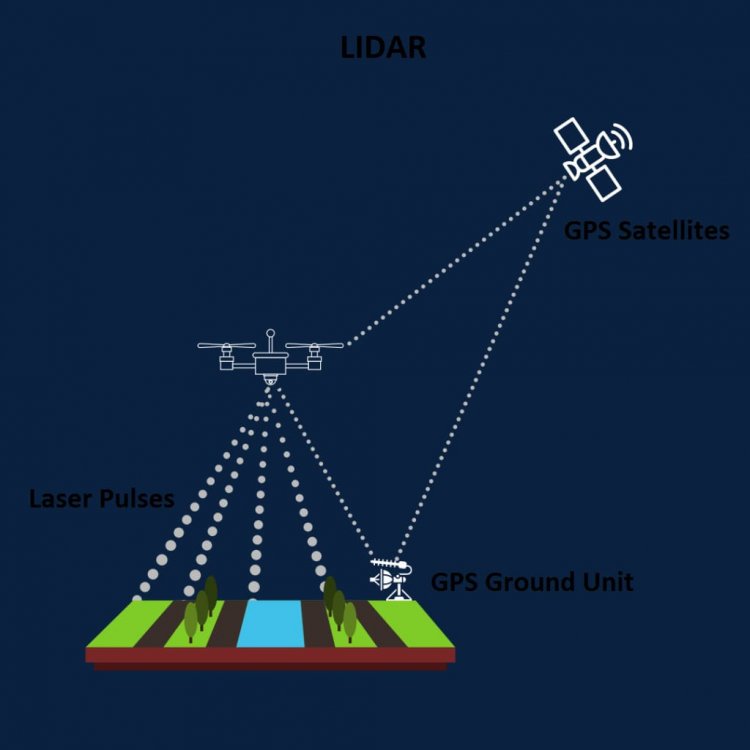
A LiDAR instrument consists of three main components: a scanner, a laser and a GPS receiver. Other elements that play a critical role in data collection and analysis are the photodetector and optics. Most public and private organizations use helicopters, drones and airplanes to obtain LiDAR data. Here's a brief overview of each component:
Scanner: The scanner is responsible for aiming the laser beams emitted by the LIDAR instrument. It usually consists of a rotating mirror or a series of oscillating mirrors that can quickly direct laser pulses in different directions. The scanner allows the lidar to cover a large field of view by directing the laser beams to the target area.
Laser: The laser is the most important part of the LIDAR system. It emits short pulses of laser light, usually in the near-infrared spectrum. These laser pulses are aimed at the target area and reflected when they collide with objects or surfaces. The energy and wavelength of the laser pulse determine the range and accuracy of lidar measurements. LIDAR systems often use solid-state lasers or diode lasers because of their compactness and robustness.
GPS Receiver: The GPS (Global Positioning System) receiver is used to determine the exact location and orientation of the LIDAR instrument. It receives signals from different GPS satellites and uses the time delay between the received signals to calculate the position of the instrument. Integrating GPS data with LIDAR measurements makes it possible to identify the geolocation of the acquired 3D data and create georeferenced maps or models. The GPS receiver also helps keep the LIDAR system synchronized with other sensors or systems, ensuring accurate data matching.
These three components work together to allow the LIDAR tool to collect detailed 3D data from the target area. The laser emits pulses, the scanner sends those pulses across the scene, and the GPS receiver provides geospatial information, resulting in precise and accurate LIDAR measurements.
Types:
1)Airborne LIDAR:
Topographic Airborne LIDAR: This type of aerial lidar is typically used for mapping and surveying large terrains. It collects high-resolution elevation data by emitting laser pulses from an aircraft or helicopter and measuring the time it takes for the pulses to return after reflecting off the Earth's surface. Aerial Topographic LiDAR is widely used in applications such as topographic mapping, floodplain delineation, and land cover classification.
Bathymetric Airborne LIDAR: Aerial bathymetric lidar is specifically designed to map underwater topography and water depth in coastal areas, rivers and lakes. It uses lasers that can penetrate water surfaces to measure the time delay of reflected pulses, allowing calculation of water depth. Aerial bathymetric LiDAR is essential for hydrographic surveys, coastal zone management and underwater terrain characterization.
2)Terrestrial LIDAR:
Static Terrestrial LIDAR:
Static-ground LiDAR systems are stationary instruments that collect highly accurate and detailed 3D data of a specific area or object. These systems use a stationary scanner mounted on a tripod or platform and use a scanning engine to emit laser pulses and detect their reflections. Ground-based static LiDAR is used for applications such as architectural modeling, heritage preservation, crime scene documentation, and industrial surveying.
Mobile Terrestrial LIDAR:
Mobile Ground LiDAR systems are designed to collect 3D data while in motion, usually mounted on vehicles such as cars, trucks or drones. These systems combine LiDAR sensors with GPS and inertial measurement units (IMUs) to accurately georeference the collected data. Land mobile LiDAR is commonly used for transportation infrastructure monitoring, road surveying, urban planning and autonomous vehicle navigation.
Portable Terrestrial LIDAR:
Portable Terrestrial LiDAR systems are lightweight, portable devices that allow users to collect 3D data by manually scanning objects or areas. These systems are useful for obtaining detailed information in confined spaces or areas that are difficult to access with other LiDAR instruments. Portable terrestrial LiDAR finds applications in forensic science, architecture, cultural heritage documentation, and small-scale investigation.
What are the problems with LiDAR?
Essentially, LiDAR is a range finder that measures the distance to a target. The distance is measured by sending a short laser pulse and recording the time between the outgoing light pulse and the detection of the reflected (backscattered) light pulse.There are several known issues with LiDAR operating systems.
These issues depend on the type of LiDAR system. Here are some examples:
1)Isolation and deviation of the signal from the emitted beam.The probe beam is usually much brighter than the return beam.Care must be taken to ensure that the sound beam is not reflected by the system and scattered back into the receiver, saturating the detector and rendering it unable to detect external targets.
2)False reflections from debris in the atmosphere between the transmitter and intended targets.Dirt can cause false reflections that are so strong that reflections from intended targets cannot be reliably detected.
3 ) Optical power restrictions.While offering more precision, a system with a higher beam power also has higher operating costs.
4)Scan speed. Safety can be an issue when the laser source operates at a frequency that is dangerous to the human eye. This problem is solved by other approaches, such as pulsed lidar, which illuminates a large area at a time and operates at eye-safe wavelengths.
5)Crosstalk signals from devices close to LiDAR devices can interfere with that signal. The problem we are currently facing is how to distinguish the signals emitted by other nearby LiDAR devices. Several approaches to frequency modulation and signal isolation are currently under development.
6)Cost and maintenance of LiDAR systems. These systems are more expensive than some alternative types of sensors, but there is active development to overcome the high cost and produce lower cost systems for wider use.
7)Deviation of reflections from unwanted objects. This is similar to false weather rejection, as mentioned earlier. However, this can also happen in clear skies. The solution to this problem usually consists of minimizing the beam size at different distances from the target, as well as in the field of view received by the LiDAR receiver.
Other applications:
The applications of LiDAR are profound and varied. In atmospheric sciences, LiDAR has been used to detect many types of atmospheric components. It has been used for the characterization of atmospheric aerosols, the study of top winds, cloud profiling, meteorological data collection, and many other applications. In astronomy, LiDAR is used to measure distances to both distant objects such as the moon and very close objects. In fact, LiDAR is a crucial device to improve the distance measurement to the moon with pinpoint accuracy. LIDAR has also been used to create reference stars for astronomical applications.
Uses:
LIDAR systems enable scientists and mapping professionals to explore both natural and built environments with precision, accuracy and flexibility. NOAA scientists use LIDAR to create more accurate coastal maps, create digital elevation models for use in geographic information systems, support emergency response operations, and many other applications.
LIDAR (sometimes also spelled LiDAR, Lidar or LADAR) is used in a wide variety of land use planning and management activities, including risk assessment (including lava flows, landslides, tsunamis and floods), forestry, agriculture, geological mapping, studies of reservoirs and rivers.
LIDAR can also be used in any situation where it is necessary to know the structure and shape of the Earth's surface and can even measure certain gases and particles in the atmosphere. Its versatility and high resolution make it suitable for archaeology, climate monitoring, urban planning, meteorology, mining and many other applications.
What's Your Reaction?